By way of introduction, my name is Phil Skelton and I am chairperson of a cycling advocacy group in Co. Wexford.
We are a group founded in 2019, comprising of around 200 members with the aim of seeking better cycling infrastructure for people of all ages and abilities.
We are a member group of cyclist.ie, the Irish cycling advocacy network and we fully endorse their submission to this process.
Our groups website is www.wexbug.org should you wish to see more..
First of all can I congratulate you both and everyone involved in the work carried out to date on this most important project.
This has the potential to be totally transformative.
Your vision statement is important and should set the tone for this:
“Develop a safe, connected, and inviting cycle network between urban areas and key destinations to achieve accessible, sustainable, and high-quality routes that will help to reduce the carbon impact of transport and promote a healthy and inclusive society”
The words, ‘safe, connected and inviting’ are key to the overall potential success of this spine of cycling infrastructure I believe.
I want to offer some views in this consultation but in doing so I will be drilling down a little more closely into the nuts and bolts of what is being proposed for the Co. Wexford section.
Some of it includes a declassified road with plenty of space and as such seems ripe for quick delivery.
I think that getting this right from the outset, will be important in selling the initial and subsequent overall, message to the general public.
Please see screenshot below of the section I wish to flesh out further.
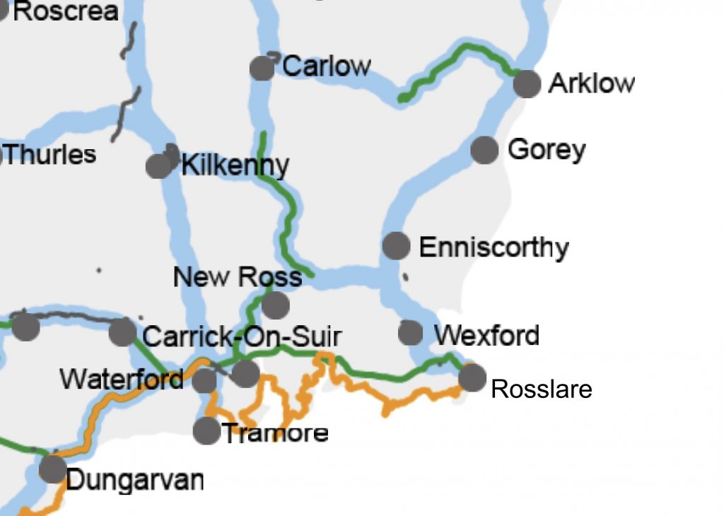
1. Greenway – Wexford Town to Rosslare
Firstly, Wexford Co Co is currently in a consultation process to deliver the Wexford Town to Rosslare Greenway but I don’t see this included in your interactive map.
What I see is what might be some type of 4km wide corridor which may/may not correspond to the existing N25 or what might be a route for the proposed Oilgate to Rosslare motorway.
This will be a key piece of cycling infrastructure for Co. Wexford and I think it is important to know exactly what is proposed for this section.
(a) The Greenway looks to be a difficult enough project and is far from a done deal.
(b) The motorway is similar and if it happens, are we proposing adjacent cycle lanes.
(c) If neither of these happen, and we end up using the existing road, this has become very heavily trafficked with HGVs now and without proper segregation will not have the appeal to attract more bicycle riders.
2. Declassified road and other opportunities.
The N11 section from Wexford to Enniscorthy seems to branch off east at around the Skurlocksbush roundabout.
This is a really good part of the plan as it has the potential to join up with the old disused Macmine rail line which would seem like an very obvious future Greenway route.
2(a). The road south of Skurlocksbush is the N11 also looks to be included in the NCN map.
(It’s of note too that the Wexford draft Co. development plan includes a Blueway for the River Slaney and as such given the 4km corridor scope, that it could also apply to that)
This road currently has wide hard shoulders and segregation beyond that of a strip of paint, will be key here on a road with a 100km/hr speed limit.
Proper cycling infrastructure will need to be added in the village of Oilgate instead of the poorly designed, mislabelled shared paths that end abruptly that occupy pride of place, there currently.
2(b). The road north of Skurlocksbush is part of the declassified N11 (now called R772). This section is ripe for a quick delivery project as there is plenty of available space there.
Proper segregation will be required in order to make this ‘safe, connected and inviting’ I believe.
Further thought will need to be given around getting from one side of the road to the other to cater for those needed to turn off etc.
Enniscorthy
This road then leads on through Enniscorthy.
Last year, Enniscorthy became the only town or city outside of mainland Europe to be awarded a ‘Tour de France cycle city’ label which remains completely untapped in to.
(See blog below for further information)
This could provide an opportunity the make Enniscorthy a hub town and I’m not convinced from your presentation that the right investment is going to be made to deliver on that potential.
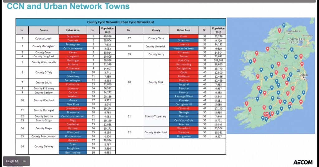
From your presentation on Thursday, Enniscorthy will not be included in the urban cycling network plan (see screenshot below) which I think is a mistake.
Continuing the NCN through Enniscorthy without there being an urban network plan will not only be an opportunity missed, but will also be difficult to achieve I believe.
(Screenshot from the NCN presentation showing Enniscorthy not included as urban network town)
Underpasses and links
As we move north along this proposed route, we encounter many roundabouts and we will need to look at options including underpasses and link roads for these to make it an attractive option for all ages and abilities.
Further north, the route seems to go through Ferns village.
I’m struggling to see a route through the town here and maybe a cycling bypass with a spur link into town might be the best option.
This road then leads on through the village of Camolin where the 9 stones route joins it.
This official Wexford Co. Co. mapped and signed 9 stones route is exclusively a sports cyclist route with many challenging climbs and as such, in its totality, may not be an easy fit for the NCN design criteria.
The first person experience of cycling this route is no different than cycling along any random Co. Wexford road except for the road signage.
Greyways:
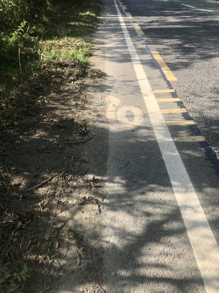
Moving further northwards along the R772, we come to some work that Wexford Co Co has done in the name of Greyways.
Basically here the council has added some white paint inside a existing hard shoulders (irrespective of hard shoulder width) and added a bike symbol to the road.
These also act as shared spaces with pedestrians and it’s unclear whether any future iteration will cater for pedestrians?
Greyways though, have been a monumental failure and provide nothing outside that of a symbolic and sometimes dangerous, marking of territory.
If we are to hit the word ‘attractive’ the National Cycle Network MUST avoid these at all costs.
Full segregation with a guaranteed maintenance programme can help achieve the status of ‘inviting’ for such roads.
(Pic below is from the existing greyway)
We believe that Wexford Co Co has applied for and received funds in excess of €250,000 to add more Greyways from Skurlocksbush to Clogh under 2020 active travel measures.
The council’s vision for these was more road paint while WexBUG’s contention was/is total physical segregation.
Our group liaised with the council at the time for them to not proceed with this until national standards had been applied. Thankfully we were successful in that regard and we might have saved a very expensive road paint burning off exercise now.
However, the ‘completed’ road section from Gorey to Clogh and the road north of Gorey will need to be revisited, I believe.
I can share our email and pleas with you if you wish to understand the issues further.
I would also encourage you to read the attached blog below for a better understanding of Greyways.
https://wexbug.org/what-are-greyways-and-are-they-value-for-money/
3. EuroVelo1 – Co. Wexford section.
The Co. Wexford section of the EV1 is a great route but is unfortunately let down by real poor road surfacing in places.
(See image below.)
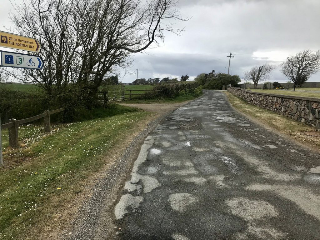
Whilst this route is usually a low trafficked one, it can get busier during Spring or harvest time when more agricultural machinery is on the move.
The route is on mainly 80km/hr roads too making this a difficult choice for a parent to bring a child along with them for example.
The route whilst being scenic, isn’t very direct between villages on the route.
I think for this route to be included on any NCN, speed limits will need to be reduced and weaker sections of really poor road surfacing will need to be identified and rectified. Traffic calming measures such as give way pinch points such as we see on some roads overseas would also be needed I believe.
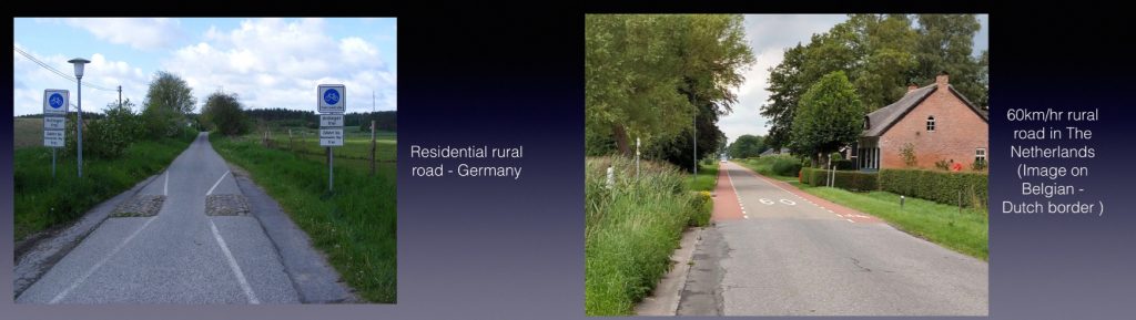
These same principles should also apply to future ‘Rothar Roads’ I believe.
With almost 3,000kms of ‘L’ roads in Co. Wexford, this could present excellent opportunities to develop Rothar roads in to our county network.
(See images below from Left – Germany & Right – Netherlands)
4. New Ross to Waterford Greenway.
This route has been included in the all island rail review and serious doubts exist regarding its delivery as a greenway.
With this in mind, it would be my belief that the NCN should explore a contingency direct route from Wexford Town to New Ross maybe following the route of the N25.
5. Further suggested routes.
(a) I think that some thought needs to be put in to the addition a more direct route between Wexford Town and New Ross.
Currently the N25 gives drivers a very direct route between these two towns but the NCN has a suggested longer trip via Scurlocksbush.
Is it possible to take a closer look at the provision of cycling infrastructure along or adjacent to the N25?
(b) I think some thought needs to be given to adding a link to Bunclody via Enniscorthy as part of the NCN. Bunclody is quite a popular area for particularly leisure cyclists and it seems to have missed out. (I note that in the Co. Wexford draft Co. Development plan, there is mention of a Blueway from beyond Enniscorthy to Bunclody and perhaps this will be included in the County cycling network plan)
Other:
‘The NCN will be clearly signposted to identify and distinguish it from other cycle facilities’
The best system that I’ve come across is a system used in Belgium and the Netherlands called the numbered junction network.
I think this system should be considered for our Irish network.
You can read more about it at this link:
Junction links.
I think it will be really important that the NCN comes complete with excellent hi quality junctions designed to best international standards.
For areas of the network where county network spurs are to be added at a different stage, I think there needs to be an obvious high quality link for the council’s cycling infrastructure to seamlessly join on to.
Consideration should be given to safe open underpasses along with ‘Dutch Style’ roundabouts, cycling priority traffic lights etc., where appropriate.
Quantified targets.
It is unfortunate that the Co. Wexford draft County Development plan does not have specific targets set for cycling as a mode of transport.
This would also seem to be a shortcoming in the NCN document.
Many thanks for taking the time to read through this and I look forward to you confirmation of receipt and acceptance in your reply.
Yours,
Phil Skelton
Wexford Bicycle User group (WexBUG) Chairperson